Please use this identifier to cite or link to this item:
https://elib.psu.by/handle/123456789/18468Full metadata record
| DC Field | Value | Language |
|---|---|---|
| dc.contributor.author | Маркович, К. И. | - |
| dc.contributor.author | Макарова, М. В. | - |
| dc.date.accessioned | 2017-01-11T06:37:08Z | - |
| dc.date.available | 2017-01-11T06:37:08Z | - |
| dc.date.issued | 2016 | - |
| dc.identifier.citation | Вестник Полоцкого государственного университета. Серия F, Строительство. Прикладные науки. - 2016. - № 8. - С.139-142. | ru_RU |
| dc.identifier.issn | 2070-1683 | - |
| dc.identifier.uri | https://elib.psu.by/handle/123456789/18468 | - |
| dc.description | Analysis of Obtaining Normal Heights Points of the Earth’s Surface Using Data From Satellite Measurements and Models of the Geoid K. Markovich, M. Makarova | ru_RU |
| dc.description.abstract | Представлен анализ возможности получения нормальных высот точек земной поверхности с использованием данных спутниковых измерений и глобальных гравитационных моделей Земли. Выполнена оценка точности моделей геоида EGM2008, EIGEN-6C4 по разностям аномалий высот, вычисленных для пунктов геодезической сети учебно-научного полигона Полоцкого государственного университета по инструментальным данным и данным моделей.=The paper presents an analysis of opportunities for normal heights points of the earth’s surface using satellite data and global models of the Earth’s gravity. The estimation accuracy of the geoid models EGM2008, EIGEN-6C4 on differences height anomalies calculated for points geodetic network of educational and scientific polygon Polotsk State University on instrumental data and data models. | ru_RU |
| dc.language.iso | ru | ru_RU |
| dc.publisher | Полоцкий государственный университет | ru_RU |
| dc.relation.ispartof | Веснік Полацкага дзяржаўнага ўніверсітэта. Серыя F, Будаўніцтва. Прыкладныя навукі | be_BE |
| dc.relation.ispartof | Herald of Polotsk State University. Series F, Civil engineering. Applied sciences | en_EN |
| dc.relation.ispartof | Вестник Полоцкого государственного университета. Серия F. Строительство. Прикладные науки | ru_RU |
| dc.relation.ispartofseries | Серия F. Строительство. Прикладные науки;2016. - № 8 | - |
| dc.rights | open access | ru_RU |
| dc.subject | Государственный рубрикатор НТИ - ВИНИТИ::ЕСТЕСТВЕННЫЕ И ТОЧНЫЕ НАУКИ::Геодезия | ru_RU |
| dc.subject | спутниковые измерения | ru_RU |
| dc.subject | разности аномалий высот | ru_RU |
| dc.subject | точки земной поверхности | ru_RU |
| dc.subject | satellite measurements | ru_RU |
| dc.subject | point the earth‘s surface | ru_RU |
| dc.title | Анализ получения нормальных высот точек земной поверхности с использованием данных спутниковых измерений и моделей геоида | ru_RU |
| dc.type | Article | ru_RU |
| dc.identifier.udc | 528.21 | - |
| Appears in Collections: | 2016, № 8 | |
Files in This Item:
| File | Description | Size | Format | |
|---|---|---|---|---|
| 139-142.pdf | 199.08 kB | Adobe PDF | 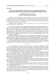 View/Open |
Items in DSpace are protected by copyright, with all rights reserved, unless otherwise indicated.